This day snuck up on me storm wise, as I remember being surprised when I saw the tower to our south
(Photo 1).
I had just washed my 2nd generation Mazda RX-7 and had gone driving around the lake with my girlfriend.
We cut the drive short when we saw the storm to our south and I wanted to beat it back to Borger.
About halfway back to Borger my sunroof was giving me trouble and was stuck in the open position, which only added to the tension.
I was able to beat any of the rain and went to the south edge of Borger to get a better look at the storm headed our way (Photo 2).
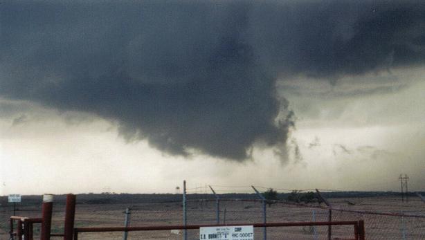
Shortly after getting a view of the rain free base approaching Borger from the SW, a wall cloud quickly wrapped up a few miles west of town
(Photo 3).
It was at this point my girlfriend said she needed to get home, but the hail was a major concern for me. My concerns were later verified with baseball size hail at her house on the north side of town.
We let the main wall cloud pass over Borger and then drove up into the back side of the hook
(Photo 6). Just after getting to my house in the middle of Borger golfball size hail began to start, so i jumped back in my car and bailed south and east.
As I got to the east side of Borger, I followed the roation out to near Skellytown where a handful of chasers and a radar truck were positioned
(Photo 8). The storm had moved too far NE to see anything at that point, so went back to Borger.
I picked up my girlfriend and went to her house to find a good amount of hail damage done by baseballs. Their yard had impact craters a couple inches deep. The cars took the worst of the damage.
Photos:


Here is the SPC outlook for May 23, 2002

Here is the map for storm reports for May 23, 2002.

I found a few links to some other chaser pages that have some radar images and other useful images from the this day listed below.
Links:
SPC outlooks and weather data


